Back to Dispatches from Field School
Field School 2019 – Week 10
Travis Parno – HSMC Director of Research & Collections
“A Conclusion to the 2019 Field School”
It’s hard to believe, but the ten weeks of the 2019 Field School in Historical Archaeology have come to an end. Our students are hard at work on their last task (the final exam), leaving me some time to reflect on an incredibly productive program. We excavated 18 five-by-five foot units, and unbackfilled two more, across two very different sites. Our students braved extreme heat and a bit of rain to complete a lot of work that has led to some significant insights. In today’s post, I’ll review what we’ve learned this summer and look towards the future to see what we still have left to complete.
At the end of May, after some introduction to Historic St. Mary’s City and to artifact identification, our team headed out to the Mill Field. We would spend the first five weeks of the program exploring an area adjacent to the site of excavations conducted in 1992. Our time in the Mill Field proved to be a great introduction to archaeological methods. The stratigraphy at the site consisted of a thin layer of topsoil and then approximately one foot of plowzone, a layer of materials mixed together from hundreds of years of agricultural activity. The straightforward stratigraphy meant that our team could move soil at a rapid rate; we excavated twelve units in just several weeks.
Our excavations in the Mill Field revealed the edges of an intriguing feature: a broad midden that seems to be related to the deconstruction or destruction of a late 17th-century building. A portion of this structure—its chimney base located on the eastern end of the building—was identified during the 1992 excavations. Our work was situated roughly 35 ft. northwest of the chimney. In the units that were located closest to the structure’s original location, we encountered a layer beneath the plowzone consisting of dark brown soil with many fragments of brick and charcoal. Also discovered in this layer were sherds of late 17th-century ceramics, including notable amounts of manganese mottled ware.
While we were able to accomplish a great deal in terms of unit excavation in the Mill Field, we quickly learned that the soils at the site drained incredibly well. This, combined with the heat of the early summer, meant that features were very different to discern from the local subsoil. As a result, we left much of our documentation to be accomplished later this fall. Once we finish up our work at the Calvert House site, we’ll be returning to the Mill Field to clean, photograph, and map the units that we excavated during the field school.
In the first week of July, the field school picked up and moved our base of operations from the Mill Field to the Calvert House site. This year would mark the twelve consecutive year in which HSMC’s field school would spend some of its time at the Calvert House site. Our work this year began by returning to four excavation units that were started during the 2018 season but never finished. Last year, we had hoped that a large 17th-century post hole (potentially related to an outbuilding) sat at the intersection of these four units, but we quickly learned that the feature was instead an even larger 19th– or 20th-century planting hole. We spent a long time carefully exposing the planting hole, determining where it began in the stratigraphic profile, and where its boundaries lay. It quickly became clear that the planting hole cut a ca. 1680–1690 fence that crossed the north yard of the property running east-west. As we expanded our excavations west with two additional units, we encountered additional small post holes and a corner of the animal baiting pit that has been the subject of study in previous seasons.
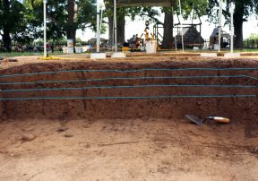
Profile of an excavation unit in the Calvert House’s north yard with blue lines indicating the various stratigraphic layers present in the yard
What was most significant about our excavations in the north yard was not anything related to outbuildings, but was instead new insight into the site’s stratigraphy. In particular, our work confirmed what I had begun to suspect during last year’s field season: the landscape of the Calvert House site was altered during the construction and use of the Brome-Howard House in a far more dramatic manner than we had initially believed. This summer’s work demonstrated that rather than a straightforward sequence of topsoil, plowzone, and subsoil (like we encountered in the Mill Field), along with a few miscellaneous layers of gravel driveway, the Calvert House site’s stratigraphy features a variety of occupation layers and evidence of soil removal. These periods of disturbance left behind only a fraction of the plowzone that we find on many of our other site’s at HSMC.
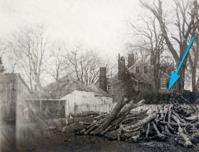
Photo of the Brome House and outbuildings ca. 1909. Note the white picket fence and the overgrown trellis (indicated by the blue arrow) that screen the work spaces associated with the outbuildings in the foreground from the view of those in the main house in the background
On top of the plowzone, we see evidence of landscape use associated with the Brome and later Howard family occupations. In the Brome-Howard House’s former front yard (what we’ve been calling the Calvert House’s north yard), the upper strata contain few artifacts. The majority of those that are present date to the 19th and 20th centuries. In the Brome-Howard House’s former side and rear yard (east and southwest of the Calvert House’s foundations), the upper strata contain a much higher quantity of artifacts, including cut and wire nails, pieces of tools, and glass bottle fragments. These upper strata and the artifacts found therein suggest that the plantation spaces were divided into public spaces (i.e., those areas desired to be seen as clean and free of trash, and thus artifact-light) and private spaces (i.e., those areas where the work of the plantation took place leaving behind a dense artifact record). In the time in which the plantation was owned by the Brome family, we can divide these spaces along the same spatial lines into white and black spaces. The front yard was where the family and visitors approached the house along the gravel driveway. The side yard and paths to and around the outbuildings were spaces were the enslaved African Americans held by the Brome family labored. Their work granted social and economic power to the Brome family, but it was designed to be obscured from view (in some periods, it was literally screened by a wooden fence and trellis that separated the main house from the outbuildings).
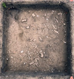
View of the top of the second layer in the filled ravine at the Calvert House site showing the many fragments of animal bone present in the layer
While working at the Calvert House site, our team also excavated an area to the southwest of the Calvert House where a ravine used to feed into a nearby gulch. In the 17th century, the ravine provided the perfect place to dispose of trash. Previous excavations in the ravine had not identified any stratigraphy, but did reveal that the ravine was filled with up to 1.5 feet of 17th-century refuse. Work in the ravine is slow because it requires precise documentation, the collection of soil samples for scientific testing, and multiple types of screening. So far, we’ve excavated the upper layer of the ravine fill and identified the start of the second level. Not surprisingly, we’ve encountered a massive amount of animal bone, along with late 17th-century ceramics, lots of pipe fragments, and some expensive table glass. We look forward to continuing our work in the ravine feature into the fall and seeing what fascinating artifacts emerge.
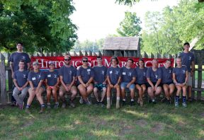
As the 2019 Field School in Historical Archaeology comes to a close, I think of how proud we are of the 12 students who came through our program this year. We’re so grateful for their hard work and we’re confident that they’re bound for great things. We can’t wait to see what they do next!


