
2011 Week 4
Various weathermen report that this has been the second warmest June on record. They would get no argument from the field school. We have taken to putting our dirt in buckets and hauling it to the screens set up in the nearest shade. Even deep features, like an excavated sewer line trench, have provided a respite from the sun.
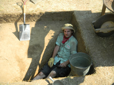
Joseph Clemens takes advantage of the shade provided by a deep feature.
The forecast for next week is for cooler and less humid conditions. If only they could throw in some rain as well.
We are at the halfway point for field school by the end of this week. Five weeks in and five weeks to go. At the halfway point, we have already achieved much of what we set out to do. The area which was formerly under the Brome-Howard House has been partially tested and our excavations in the southwest corner of the site are filling in big gaps in the sample. We have added significantly to the understanding of the fence pattern in the back yard. Previously we had been following an early (pre-1645) fence line trending northeast across the backyard until it abruptly ended at a post hole. This week, we found the continuation of that fence with its matching post hole.
An early fence line ending at a gate and cut by a later fence line.
The two post holes form a space for a gate and this information allows us to see traffic and use patterns in the yard from the early period. Just because nothing is ever simple on this site, the early fence and post hole are cut by a latter fence.
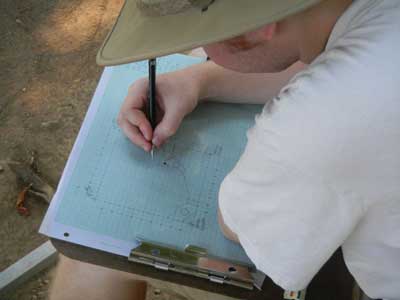
An area 10 ft. by 10 ft. has been opened over the plaster/mortar feature discovered earlier and its identification as a cellar hole is looking much better. Several post holes have been found associated with the feature which suggest a structure stood above it. While most people think that digging is the archaeologist’s most important job, in reality, we spend most of our time recording what we find. Without detailed records, there would be no way to fully understand the site. To help our precise recording, we use a mapping frame. The interior of this aluminum frame is exactly 10 ft. by 10 ft. and there are tapes on both sides and the cross-bar.
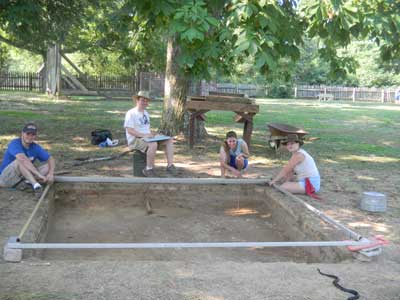
Jerry Warner, Kyle McGrath, Irene Posey and Jean Drzyzgula map the possible cellar hole.
This allows us to accurately locate any point and transfer that information to the drawing. After 30+ years of archaeology, we have boxes and boxes of these drawings and they form a major portion of the record of what we have learned. The photo shows a typical mapping crew with two students on the sides and one in the middle with a plumb bob. The final member is the drawer who sits facing north so they can record the points on the drawing. In the lower right hand corner of the photo, you can see an unexpected visitor who would soon make everyone forget about mapping for a time.
Our brief encounter with nature in the wild being over, work on the map began again.
Kyle McGrath drawing the plater/mortar feature.
The photo shows much of the drawing process. The 10 ft. by 10 ft. unit has been limited by a dot and dash line and numbers outline the grid all around the drawing. Each feature is first outlined by dots representing measured points. Then the dots are connected by lines showing the shape of the feature. Once the lines are completed, we add symbols for such things as brick, gravel, shell and mortar in each feature. The features are then shaded according to the darkness of their soil matrix. Each feature is given a number and a detailed soil description is written for that number.
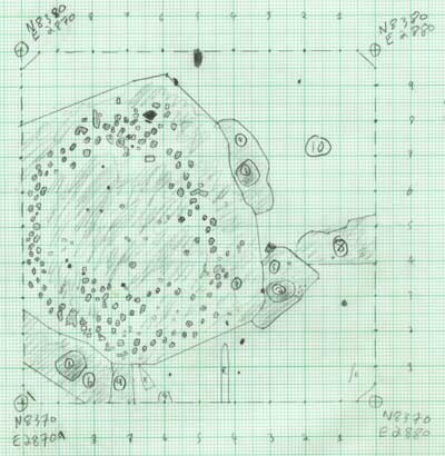
Completed drawing of the possible cellar hole.
The finished drawing reflects what was seen at the time of excavation.
Looking at the drawing, several significant things are evident. The post holes are all cut by the larger feature but their post molds are not. This suggests the posts were in place when the possible cellar hole was dug and later filled. The plaster/mortar seems to be in a circle. This is a result of the process of filling the hole. As a deep hole is filled, the area close to the walls fill first making later layers slope inward. What looks like a circle in this plan view would look like a sloping soil layer were we to excavate the feature. We are currently excavating the units adjacent to the west side to fully expose the limits of the feature.
The southwestern area of the site has been yielding large quantities of artifacts as would be expected from the midden outside the kitchen of the Calvert House. A number of beads, whole pipe bowls, large pieces of ceramics and other significant items have been recovered. One of those items was a lead bale seal from the city of Norwich in England.
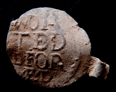
Lead bale seal from Norwich.
From similar artifacts found in England, we can complete the inscription as “WORSTED REFORMED,” and was a seal used by the “Worsted Company” of Norwich from the last quarter of the 17th century to 1705, when they stopped using lead seals. This is only a portion of the whole seal. Directly opposite this would have been a figure indicating the number of yards of cloth in the bolt. Another part of the seal would have “Norwich” on one side and the initials of the Company Warden who inspected the cloth. These seals were important both for the quality and reputation of the guild making the cloth as well as for tax purposes. There is always something special in finding an artifact that can be tied to a specific time and place.